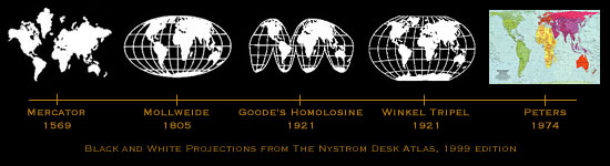
The Peters World Map was developed in 1974 to give a size accurate portrayal
of the world. The problem with developing any two dimensional map is
how to display the third dimension. Peters, in developing his map accurately
portrayed the size of all nations, rather than displaying their correct
shape. This is in contrast to the dominant map, the Mercator map developed
in 1569 which accurately depicts the shape of the land masses, but severely
enlarges the size of the northern hemisphere. Peters' map allows the
reader a proportional representation of area, which also allows the
reader to accurately plot the coordinates on the map. Peters feels the
minimalization of size distortion allows equal representation, giving
a voice to underrepresented countries in the developing world.